Friday, August 22, 2008

Oregone

Our four hour journey snaked us through the valleys as we headed north. Huge mountain sides filled with evergreen trees towered over the road and made the cars and trucks seem like toys as they rolled past these giants.

We had one stop to make and we knew it was going to be a painful one, in our wallet. When we drove through California we didn't stop once to fill up with Diesel since the prices are so high there. We managed to make it the entire state but entered Oregon on fumes. We had to drive about 60 miles to the nearest Truck Stop and with every big hill we had to climb the needle would disappear on the gauge, empty. Come on Road Hazard don't fail us now!

We made it to the pump but now had to shell out over $500 to fill the empty belly of the beast. The price of freedom isn't cheap sometimes.

Reta and I are excited to be arriving in Portland because our good friends have moved out here several years ago and we only get to see each other maybe once a year. After we set up Road Hazard we took off to go visit. With a warm reception, complete with sidewalk art, we visited into the late evening. Already planning the next days events.

One thing of note that we discovered...you pronounce it OREGEN. Never say OREGONE. The locals don't seem to like it.

Wednesday, August 20, 2008

Table Rock

Our last day in Grants Pass was a game of Hide & Seek with the sun as the rain clouds would cover it up and expose it throughout the day. Our plans of driving a couple of hours to see Crater Lake was washed away with the morning rain. After sitting around Road Hazard for most of the day we decided to go for a hike up to Table Rock that sits about 2000' above the valley floor.

It felt good to be outside getting some fresh air and stretching our legs. It seemed we had a little extra bounce in our feet as we started up the trail. The reason we chose this trail is because there has been some BIGFOOT activity recorded in this area. I am determined to spot the elusive beast. With my camera fully charged and at the ready we took off.

There sits the flat volcanic rock now named Table Rock. It would take us about an hour to hike up to the overlook. The trail started off through a wooded area. Home, of course, to Sasquatch. Around every bend in the trail I was at the ready to snap the award winning photograph.

We finally made it to the top of the table and was greeted by heavy rainclouds descending through the valley. The wind was constant and kept the clouds away from the plateau that we were traversing. As we got closer to the edge a few drops of rain made an appearance but was short lived.

As we stood with our toes at the edge overlooking the valley below another rain cloud had pushed through Grants Pass and was building to come south where we were. Enjoy the view and lets go before we get hit with a wall of water. It was hard to leave this spot because the view was great. Large vultures floating effortlessly in the updrafts, coming off the rock face, that only seemed feet away from us. The activity on the valley floor looked as if we were watching ants scurry about. Come on, let's go!
We made it back with only a few showers keeping everything cool and moist on us. No sign of Bigfoot but there will be other opportunities to spot him.
Thursday we are on the road again and still heading north. Next stop...

Tuesday, August 19, 2008

Vortex Center

So, after much research Reta wanted to check out the "House of Mystery" also known as the Vortex House. It's a Must See to Believe! Here is a statement from their website explaining the house.
"The Oregon Vortex is a spherical field of force, half above the ground and half below the ground. The word "vortex" simply means a Whirlpool of force, like a whirling mass of water, especially one in which a force of suction operates, such as a whirlpool or a whirling mass of air, especially one in the form of a visible column or spiral, such as a tornado."
We entered the "force field" and are were given Divining Rods to find the cross sections of the vortex. Here is Reta watching the rods move in her hands to form an X as she gets closer to an intersection.

There are platforms that intersect the vortex's and if one were to stand on the north side of the cross section with another person standing on the south side, it would appear that the person on the south is taller. We did several experiences to make test the theory and every time it would appear the taller / shorter thing would always happen.

There is an old miner's house still left on the property from the Gold Rush time. It has seen better days and has collapsed on one corner. Today it is a plethora for experiments of testing the force field. What seems to be slanted one way is actually going the other. Where a bottle is rolled, on its own, uphill. Golf balls roll along uphill on a board. Broom handles stand erect leaning toward north by a few degree's.

It was an interesting day that really blew our minds and our perception was tested.
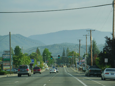
We headed over to Central Point for lunch and discovered small town America. One street that is Main Street. It had mostly Beauty Parlors. I think we counted 5 in a two block area. With so many around you would think that all the women would be incredibly beautiful. I managed to snap a picture of one coming out of the Parlor...
There's something about her eye's that just pull you in.

Monday, August 18, 2008

The Pass

Today we drove up through the mountains of Northern California and Oregon. The road was challenging and required the driver to be on top of their game. Narrow bridges, construction, steep grades were a few of the obstacles that had to be faced. Finally we arrived in Oregon.


Our first destination in Oregon is Grants Pass. Here we hope to enjoy some better weather. We left California under a light mist of rain. Something we haven't seen in 3 months. Here in Grants Pass the sun greeted us and warmed our faces as we sat outside enjoying a cold beverage after a grueling drive through the mountains.


Downtown Grants Pass is your typical small town. A small Historic District filled with shops and restaurants that all close at exactly 5 everyday.


We did find a local watering hole and went inside for some local liquid. People here are very friendly and willing to help you with local attractions. Most of the people in the bar are born and raised in the area.
We did experience a first here...Fried Asparagus. Oh so good. We are definitely going back again for some more. Armed with a map and dozens of notes we headed back to Road Hazard ready to go out and explore this area.

Sunday, August 17, 2008

First Time...

Earthquake shakes Humboldt
The Times-Standard
Article Launched: 08/16/2008 11:07:32 PM PDT

A small earthquake, measuring a preliminary 4.6, shook northern Humboldt County Saturday night, just before 11 p.m.
According to the U.S. Geological Survey, a light earthquake occurred at 10:56 p.m. The magnitude 4.6 event occurred 14 km (9 miles) north/northwest of Trinidad, at a depth of 11 miles. The extent of damage, if any, is as yet unknown.


I was settled in getting ready to watch Michael Phelps break the Olympic record when all of a sudden the entire RV started to shake. It felt like the entire thing was moving about 6 inches each way. Reta was sound asleep and came running out of the bedroom to see what I was doing. She thought that I was jumping up and down. It lasted for only 10 seconds but it left me... stunned.

Not really knowing what happened I grabbed a flashlight to go outside and inspect the jacks and RV. Slowly others started coming out as well and walking around their rigs. Then you heard one person ask another "Did you feel that?"

I'll confess to you that I couldn't go to bed until well into the wee hours of the morning. The whole experience, albeit short, left me traumatized. What would happen if a bigger one came along?

We felt our first earthquake but I don't like it. This isn't for me. Get me out of here!

Saturday, August 16, 2008

Touching the Sky

No surprise that we awoke in the midst of a think blanket of fog. We decided to make the best of it and went out to explore. Our first stop was Fern Canyon north of Orick. The way to the park was a dirt road off the main highway. A dirt road that painted the vegetation a dirty tan color from all the vehicles passing by. The road resembles a slithering snake as it winds around the big redwood trees. After 8 miles of bouncing along we finally arrived at the base of the canyon.

As you start to walk up the canyon it seems to come to life with the wind blowing through the ferns. It's almost like they are reaching out to you as you pass by. The sound of the rolling creek is the only sound heard as you walk along the wet rocky canyon. The ferns thrive in the shadows of the giant trees and the moist fog that lingers around.
On our way back to the car the local inhabitants came out for lunch. These huge Elks look very intimidating with their pointy rack displayed proudly. That's close enough for me!

Climbing back out of the dirt road we found our way over to the Northern Redwood Park. This is home to one of the few virgin Redwood Forests. Here the trees have been standing for over 1,000 years and show their scars of ancient forest fires. The unpaved path leads you around this 2 miles of Redwood skyscrapers.

It's amazing to look at the base of these giant wood structures. How can a tree be that big around? Then, as you wrench your neck to look skyward for the top, you realize that the base is needed to support such a tall tree.

When you find a fallen giant you can begin to appreciate the size of these trees.
Hopefully in the next few pictures you will have a better idea of just how big these trees are.

Eureka I Found It!

Our new home for the next several days is Eureka, California. It sits between both National Redwood Parks. Getting up here was an interesting drive. One of the most challenging drives we've had since we started. The word that comes to mind is "tight". We took Route 101 to follow the coast but it also takes you up steep mountains and through the Redwood Forest. The driving through the forest was the challenge as it takes you within inches of tall trees that sit along the side of the road. The turns are sharp. You can look in the side mirror and see the car we are towing in the turns.

It was worth the white knuckles because we went to Agate Beach today and were met by this great view. It is called Agate Beach because there are very old lava tubes off shore that are filled with Agate that was formed when the tubes cooled off. Today, the surf breaks apart the tubes and washes the semi-precious stones onto the beach.

There really is no sand on the beach but stones of varying sizes. Small as the point of a pencil to potato size rocks. People are all over searching for their nugget of stone in the multi-colored expanse.

The fog, which has been following us since LA, lingers just above the surf adding the effect of mystic to the beach.

Walking along the shore and getting our toes wet was a new experience. To say the water was cold is an understatement. When the wave rolls up along the shore tossing the little stones in its surge it causes a sound I've never heard before. Tumbling rocks knocking together with each one making a musical sound, added with the sound of the surf pounding the ground sending that thumping sensation in your chest.
When we left the beach it seemed our cloths were dragging on the ground from the weight of stones we were carrying in any pocket we had on our garment.

Thursday, August 14, 2008

Goodbye SF

With our last day in San Francisco we headed off close to sunset to get a glimpse of the city at night. What we got was a nice view of fog at sunset.

Cavallo Point is a beautiful area that looks at the Golden Gate Bridge and the city of San Francisco. As we sat at and enjoyed dinner we watched the bridge slowly disappear as the fog swallowed everything in its path.
With the sun shinning behind the mountains covered in fog we said goodbye to this area and prepare for our next destination further north.

Wednesday, August 13, 2008

Can You See Anything?

What we discovered today is that August is the time of year that this area gets fog. It lasts all day along the coast. Because of the fog it keeps the temperature way down as well. It forms an umbrella over everything and blocks the sun from heating up the ground. Fog is vital to this area because it supplies water to many plants and animals. We visited Muir Woods that is home to giant Redwood trees. Sitting near the coast these thirsty trees soak up the fog and will consume between 300 to 600 gallons of water a day during the summer months.

You can understand their thirst when you see how big they are. The base of these trees can be 22' across and the branches can reach up to 375'. The bark is thick to protect the tree from fire, insects and fungi. It can be as thick as 6 to 12 inches.

When walking among these giants it is an awe inspiring moment. Just think, these trees have been around for 600 years!
By the time we left the giants the sun was shinning and we figured it was time to head to the beach.

The beach, of course, is on the coast so there is fog.
I'm sure the views from this cliff would be incredible when there isn't any fog. We were about 400' up and the only thing we could see was the surf breaking down below.
We drove up Route 1 and by the time we reached our destination we were shaken up, bounced around and twisted about from the road. Beautiful views if you dare take your eyes off the twisty road.


Tuesday, August 12, 2008

If you have ever put a glass of wine to your lips then you must visit Napa Valley. This is the mecca of vineyards in North America. The valley here is prime real estate for growing these vines that produces world famous nectar of the Gods.

We took a tour of a vineyard to see the behind the scenes of how the process works. It started at the very beginning. In the vineyard. Walking the countless rows of vines and learning about soil, sun and sugar levels. To stand on a hill and look out over acres and acres of vineyards is a sight to see.

Once the grapes are squeezed the juice makes its way into these oak barrels and will remain here for 6 months to 2 years. The cellar felt nice and cool compared to the hot sun out in the valley. The air was filled with the mixed smells of oak, grapes and an ancient cellar. The process still remains very labor intensive. By this point we had seen the process, learned about the process and now it was time to taste the results of the process. Oh, it was very good. We each tried 6 different types of wine. Some were sweet with a clean taste while others were filled with fruity tastes and hints of oak.

When we were leaving the valley we saw a sign on the side of the road advertising a Geyser. A geyser? I thought that was only in Yellowstone. We figured why not. We're here so we might as well do the tourist thing and pay the $7 each to see what this is. My fear was that there would be a hose squirting water. To our surprise we found that this geyser is one of 6 in the world. It blows about every 40 minutes and reaches heights of around 60 feet.
Right on que it started as a small bubbling fountain and soon stretched up to 60 feet of 350 degree water being stretched up into the clear California sky. What a great find and a way to end our experience in the valley of Wine.

Monday, August 11, 2008

Downtown SF

The morning fog seemed to have burned away this morning but for dramatic effects the fog remained around the Golden Gate Bridge. The path leading down towards the base of the massive expanse lends itself to vistas of the bay. The water is a blue green color and looks almost inviting to get in until you look out further and see the strong currents pushing anything that gets into its path out to sea.

As you look south from the orange structure you can see a little spit of land sitting between San Francisco and Oakland. Here sits Alcatraz, haunted by stories of criminals that called this home for years. Today it serves as home for numerous birds that are slowly painting the buildings with their own mixture of white paint.


Across the water sits downtown San Francisco. Filled with streets that dissect the hills that makes your lungs burn upon reaching the summits. Down by the water is the Famous Fisherman's Wharf. The piers around this area are filled with shops and restaurants. Crowds are as thick as the fog that still looms around the orange structure.


Pier 39 is filled with the locals that at one time only stopped by on their migration. Today there is a small group of seals that call these wooden floating structures home year round. As you get closer you are greeted by the loud barking as they jockey for position atop these floating homes.


We spent sometime watching these animals in their natural habitat as they played, pushed and fought each other for dominance position.

If you go to San Fran then you have to walk up to the most crookedest street. You've seen this street in countless movies. The streets to get here are very steep and once you arrive and look up it seems that it is almost straight up. The road winds down between beautiful gardens and tourists lined along the sides taking pictures and taking it all in.


As we headed back towards the car, which was parked near the Golden Gate Bridge, the fog was still there but illuminated by the setting sun giving it a Hollywood type of closure to the day. From all the cities that we have had a privilege of visiting while on our journey, San Francisco is by far one of the prettiest cities. With the balance of nature and concrete structures always on display the whole scene puts you in a relaxed state of mind, even with all the chaos of people are cars always around you.


Saturday, August 9, 2008

Balance of Land and Water

With our first glimpse of the San Francisco area we were left with a sense of peace and balance. We arrived at a city called Sausalito. One of the first images we saw was of this guy sitting along the water. He was balancing rocks that were as small as a golf ball up to rocks so big he was straining to lift into position. There is no glue to keep these stones in place but just patience and skill. When you start to look around you begin to understand the symbolism here.


You notice that the homes are built on the cliffs of these mountains that tumble into the water. Like the stones, these homes are balanced just perfectly on the cliffs. Almost like a deck of cards, one on top of the other. Each, it seems, fighting for a glimpse of the amazing views below.


When you look on the water you have what seems to be a chaos of boats and masts everywhere you look but on closer inspection you realize that these boats are alined perfectly in their slips and seem to be waiting for their turn to sail on these prestine waters.


As the sun starts to dip lower in the sky the clouds start to form on the horizon. Almost like a giant wave the gray fog starts to roll in slowly. It tumbles over the mountains swallowing up the peaks, buildings and finally the boats drifting on the water. The majestic Golden Gate Bridge sitting proudly in the distance as an anchor of balance in the midst of the choas surrounding it.


What a great introduction to the city of San Francisco and the area surrounding it.


Friday, August 8, 2008

San Francisco Treat

Our trip up north would last about 4 1/2 hours. It started like most trips do, quite and with both of us trying to fully wake up. Eventually I fell asleep with the rocking of the RV and music playing on the radio. Oh, don't worry, Reta was driving at this point. Soon the two hours passed and it was my turn to drive and her turn to sleep.

We decided to take Route 101 because it is the most scenic. It tries to hug the coast but on this stretch between Pismo Beach and San Francisco it goes through the heart of the valley. It was amazing to see all the fields of vegetables on both sides of the road. Rows and rows of neatly planted vegetables. Some partially covered with plastic while others were tall and being harvested by dozens of workers. These workers must spend hours bend over at the waist picking. Ouch! Most of the produce on our tables today comes from this valley.

We finally arrived in Oakland and knew we were getting close when we had to cross the Richmond Bridge. It's one of the three in the area with the Golden Gate Bridge being the most famous. The city is built around these mountains that drop into the water. Fog is not uncommon around here. With the cold air coming off the ocean and meeting the warm air trapped in the valley you get constant shifting of fog. The water is a deep blue color and seems to always have white caps from the relentless wind that is always pushing on it.
We are excited to be here and explore the so many different area's. We have been warned by many to dress warm at all times while out exploring. Temperatures will be around the 70's but that is only between 1 and 4. All the other times the sun is hidden by fog or setting and the cold wind just cuts right through you. It's hard to believe that it is August. Our neighbors warned us that when we go off to explore, take plenty of warm cloths. They had to buy jackets while out one day because they didn't think it would get that cold. One of the locals told me that he can easily spot the tourist. It's the ones only wearing a t-shirt.

Thursday, August 7, 2008

What's with the Cold!

We awoke this morning to find that it was 51 degree's outside. Wait, where are we? I thought this was California. Where's the hot weather? Today's high only got up to 72 degrees, around 3 this afternoon, while Reta and I sat on Pismo Beach wrapped up in our towels and with our jackets on.

I did manage to fall asleep while the sun warmed us up and the sound of the waves crashed against the shore. Another tough day in the office.
When we got back to Road Hazard we decided to walk over to the sand dunes behind the campground. Only after we got there did I realize why Reta wanted to go. I got buried up to my head in the deep sand! Are you going to help me out?
The walk to the water is almost a mile and walking through the deep and steep sand was quite a workout. We were intrigued by what the wind created on the dunes and patterns on the sand.
Today, Thursday, we are on the road again to our next destination. You'll have to check back to see where we landed.

Tuesday, August 5, 2008

Fog & Sand

The trip started off under a blanket of fog as we skirted the coast up to our next destination. The further we went it seemed the sun was getting hotter to burn off the fog. The views that we were presented with were incredible. If you ever have the chance to drive along 1 on the California coast you should do it. The road twist and turns, takes you through small cities and the speeds are not fast but the view makes up for it.

We arrived in Pismo Beach. It's the midway point between LA and San Fransisco. We hope to take a day to relax on the beach and make plans for Frisco. It felt good to get away from LA, the traffic and the mobs of people.

The campground in Pismo Beach sits on these huge sand dunes that stretch for 1/2 mile to the beach. It felt great to run around on this white soft sand.

It made me want to stand up and Jump...

Jump everybody, Jump!